
MSA Safety adds FireGrid Map View to Connected Firefighter
- March 31, 2023
- 9:12 am

Iain Hoey
Share this content
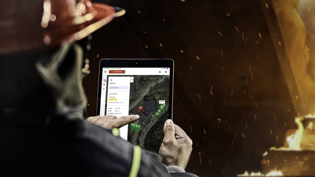
MSA Safety has released FireGrid Map View, a software enhancement of MSA’s LUNAR Connected Device. Designed enhance situational awareness and firefighter accountability, Map View enables tracking of a firefighter’s estimated location when outside of a structure.
FireGrid Map View is accessible through FireGrid Monitor, MSA’s tablet-based on-scene monitoring application. It shows a firefighter’s approximate location as a color-coded marker, using a LUNAR device’s GPS capabilities and coordinates.
By tapping on a marker in Map View, an incident commander can access additional information about a firefighter’s team assignment, self-contained breathing apparatus (SCBA) air pressure, and alarm status in addition to their estimated location.
In the event that LTE cellular connection or GPS connection is lost, Map View will display the last known location of the firefighter.
Incident commanders can see the same information for a team of firefighters, allowing for better visualisation of where team members are located and to help support the rapid decision making that occurs on scene. The three selectable views in Map View are street view, satellite and terrain.
Map View is the latest enhancement to the MSA Connected Firefighter Platform, an ecosystem of products centred around the MSA G1 SCBA that includes LUNAR, FireGrid software, HUB, and ALTAIR portable gas detectors. Together, the platform helps to keep firefighters safe, connected, and accounted for on the fireground.
Map View is now available as an update to the FireGrid Monitor application through the iOS and Google Play App stores. Compatible LUNAR devices will require a firmware update and to be registered to a FireGrid account. For more information on FireGrid Map View and the Connected Firefighter Platform, click here.