
IFSJ Exclusive: Controlling the Burn with Drone Amplified
- February 10, 2023
- 8:00 am

Iain Hoey
Share this content
IFSJ takes an in-depth look at Drone Amplified, the controlled burning tool being used as a preventative measure against wildfire
In 2020, Drone Amplified, a company that pioneered wildfire fighting using drones, signed a contract with the US Forest Service to source and vet US-made drones to fight wildfires with Drone Amplified’s aerial ignition system. The $750,000 contract was designed to increase and scale the utilisation of Unmanned Aircraft Systems (UAS) for aerial ignitions in fire management and develop the next generation of aerial ignition capabilities.
The deal followed the successful development and deployment of Drone Amplified’s aerial ignition system called IGNIS – the only UAS-based aerial ignitions payload available to the US market that is approved for use on Federal prescribed fires and wildfires.
IGNIS’s patented technology carries a payload of standard ping-pong ball sized chemical spheres and can be integrated with infrared and other types of cameras. The spheres are pre-loaded with potassium permanganate and later injected with antifreeze prior to being released. The spheres then, ignite after hitting the ground, set off back burns to create defensive lines for firefighters in rugged and sometimes unreachable terrain.
Carrick Detweiler, co-Founder and CEO of Drone Amplified and Professor at the University of Nebraska-Lincoln (UNL) started Drone Amplified based on technology initially developed at the university works. IFSJ caught up with Detweiler to learn more about the innovative approach to controlled burning.
Prescribed burning
Drone Amplified is the pioneer in developing a drone-based aerial ignition system that is able to ignite backburns to contain wildfires and prescribed fires to help better manage our lands and reduce the risk of wildfires.
Detweiler explains: “On wildfires, backburns are used to burn the fuel (dead wood, leaves, etc) in a controlled way in advance of the main wildfire front so that when the main wildfire arrives, it does not have fuel and is easier to put out.
“Traditional techniques for conducting these burns either require putting people on the ground near fire or using expensive helicopters for aerial ignition. Our system, called IGNIS, is less costly to operate, more readily available than helicopters, and keeps firefighters safer.”
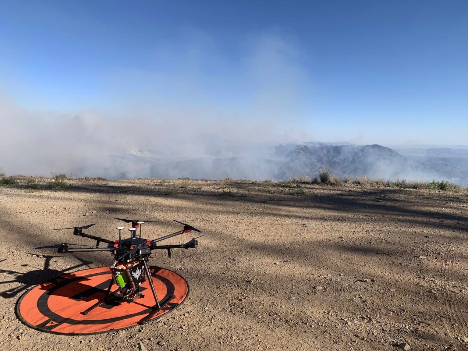
IGNIS attaches to a modified Freefly Alta X drone, which is made in the USA, and is equipped with a thermal and visual camera for situational awareness. IGNIS is tightly integrated with the drone to make easy to use in the complex fire environment.
“The ability to quickly get an eye in the sky to identify and track the fire provides an increased level of situational awareness that keeps firefighters safer,” says Detweiler. “Combining these real-time observations with the ability to quickly and safely set backburns, while keeping a distance from the fire, is changing the way that fires are managed. Firefighters do not need to just react to the fire, they can observe and change its behaviour through strategic aerial ignition.”
How it works
IGNIS uses small “ping-pong” ball ignition spheres that are also used by full sized helicopter ignition systems. “The way this works is that the ignition spheres have one chemical in them and shortly before we drop them, we puncture the ball and inject a second chemical,” Detweiler explains. “The balls then ignite 30-60 seconds after we drop them. IGNIS can drop anywhere from 10-120 ignition spheres per minute to adapt to the needs of the firefighters.”
The spheres set off backburns to create defensive lines for firefighters in rugged and sometimes unreachable terrain. IGNIS is controlled and automated with a custom app and allows drone operators to release the spheres with a high degree of accuracy in terrain that is often difficult to navigate with helicopters or airplanes. The drone’s dynamic ability to fly in densely smoky, high-altitude areas makes it extremely useful.
IGNIS ALTA X
In 2022, Drone Amplified launched IGNIS for the Freefly Systems ALTA X, the newest development in unmanned aerial ignition. Drone Amplified modified the ALTA X and IGNIS to integrate thermal and visual cameras, a customised ground station based on the Herelink Blue, and ADS-B in for situational awareness of other nearby aircraft.
Combined with the app that was designed by firefighters, the IGNIS ALTA X package comes as a ready to go field kit for the most demanding firefighting missions. It is capable of laying down miles of fire line in only a few minutes of flight. Durability and ruggedness drove the design of IGNIS ALTA X and required aggressive testing to assure dependability in high temperature, dusty and ashy environments and extreme conditions of the wildland fire environment.
Detweiler says that feedback from UAS fire operators helped refine the system into the powerful tool that has quickly gained a reputation for high performance and dependability in the field.
The IGNIS app
With features for firefighters and other organisations that need knowledge of land elevations, altitude and mapping, the IGNIS App allows firefighting teams to easily plan and execute waypoint missions to let the drone fly itself and ignite precise burn lines or use full manual operation.
It has multiple layers of safety built in, including a geofence that disallows ignitions outside the specified area, enhances safety by monitoring other aircraft in the area with ADS-B In, and maintain situational awareness by importing burn plans and maps with geo[1]referenced PDFs, KML/KMZs, and other formats for offline use.
By providing a bird’s eye map view, live video and telemetry, gimbal control, and the ability to take photos and video, the app has a range of features making it possible to interface with a range of drones, including the Freefly ALTA X, Inspired Flight IF1200, DJI drones, and others.
Firefighting teams can download elevation maps for terrain-aware flight and missions to the app which uses the maps to calculate the drone’s altitude above ground level, enabling safer flight and easier compliance with airspace regulations. Teams can see a side view of the planned waypoint mission and adjust the altitude of individual waypoints to avoid obstacles and maintain a constant altitude above the ground.
It is also possible to import shapefiles from Google Earth or georeferenced PDF files from ArcGIS, as the IGNIS app will display them as overlays on the map whilst flying and allows editing of custom KML/KMZ files. Users can configure a variety of settings on the drone and remote controller, and also perform compass calibrations with via the app. The app automatically logs flights and ignition locations to a file on the connected mobile device that can be opened by common spreadsheet programs.
Future plans
Drone Amplified is currently on the 2nd major version of IGNIS. Detweiler says they are continuously improving and advancing IGNIS and the associated software to advance firefighting technologies based on the feedback they receive from firefighters.
He adds: “We aim to continue to support wildland firefighters in any way that we can. US Firefighters have already started to change how they combat wildland fires and how they perform prescribed fire by leveraging our IGNIS system. We expect to expand more broadly to the worldwide market to help mitigate some of the risk of wildfires that we are seeing worldwide as the climate changes.”
This article was originally published in the January edition of IFSJ. To read your FREE digital copy, click here.
Images from Drone Amplified